WHAT TO DO IN MONTESPERTOLI
A TERRITORY TO LIVE
AND DISCOVER AT A WALKING PACE
The Trail of Memory
Corfecciano, Fornacette, Mulinaccio, Lucardo, Barberinuzzo

L’itinerario
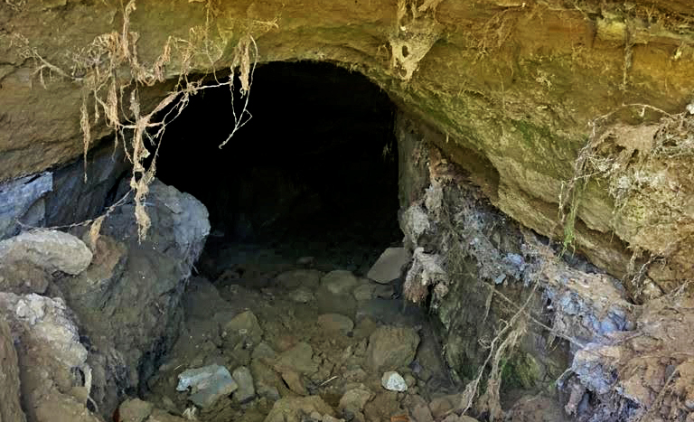
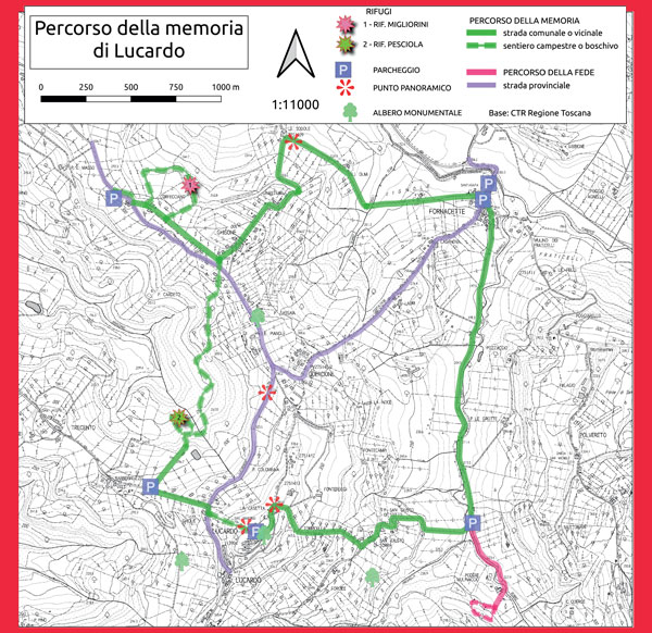
Il percorso della memoria, fortemente voluto e realizzato da La Racchetta OdV Sezione Montespertoli, collega due località in aperta campagna dove, nell’estate del 1944, la popolazione locale costruì dei ricoveri naturali, scavati nella roccia locale, cercando rifugio dai pericoli dei bombardamenti causati dall’avanzare da Sud del fronte Alleato. Insieme alle dimore coloniche, ai piccoli borghi rurali, ai luoghi della fede, alle fornaci, alla rete di sorgenti e mulini e all’architettura del paesaggio, il percorso tocca il valore profondo, identitario e memoriale della popolazione di questi luoghi. Un valore di pace che la proposta di questo itinerario intende condividere e scambiare con tutti coloro che verranno a camminare lungo questo percorso. Il percorso offre anche spunti di una naturalità concessa dall’uomo, visto che le due zone che ospitano i rifugi del 1944 sono immerse in un contesto boschivo non più tagliato da alcuni decenni. Con l’abbandono delle campagne di metà Novecento, si è assistito ad un rigoglioso sviluppo della vegetazione che presenta ora particolare pregio naturalistico anche per la ricchezza della fauna presente. Il percorso inizia dalla piccola chiesa Corfecciano e si dirige verso le case che si vedono in direzione Sud-Est, poco più in alto ma senza giungere ad esse, piegando all’altezza della vigna e scendendo a sinistra fino nel boschetto dove si trova il primo complesso di rifugi detti “del Migliorini”. Qui, nel luglio dle 1944, vi stazionavano intere famiglie con i loro animali da lavoro, preda ambita delle truppe tedesche in rovinosa ritirata. Terminata la suggestiva si risale sul crinale, in mezzo ai vigneti, per raggiungere l’antico borgo agricolo di Ghisone (l’esistenza dell’abitato è dalla metà del Trecento quale podere del monastero fiorentino di Monticelli); qui è possibile acquistare vino, olio e prodotti agricoli. Si segue in discesa la strada bianca fino alla dimora rurale delle Sodole dove svoltiamo a destra e raggiungere in breve il borgo di Fornacette. Il microtoponimo è dovuto alla storica attività di fornaci qui presenti.
Superata la strada provinciale e attraversato il borgo, si prosegue costeggiando in piano il corso del rio Virginiolo fino al piccolo ponte (il secondo), posto poco prima della località Mulinaccio; questa nel Medioevo e fino a tutto l’Ottocento è stato sede di uno dei 12 mulini presenti sul corso del Virginio; da diversi decenni vi si trova il Centro dell'”Opera Francescana della Pietà” con un proprio percorso della Fede che si sviluppa nell’area interna.
Attraversato il ponte si sale alle case di S. Giusto di Sotto e di Sopra, fino alla metà circa del Quattrocento luogo dove sorgeva una delle tre chiese medievali del castello di Lucardo e cioè San Giusto. Titolo poi inglobato nel corso dei secoli successivi nella chiesa posta sul prato immediatamente sotto il castello di Lucardo.
Oggi, queste dimore coloniche sono aziende agricole con vendita dei loro prodotti. Superata la località si continua a salire in modo più accentuato lungo una carrareccia acciottolata che punta dritta verso la sommità del colle, passando a fianco di altre dimore rurali storiche (Torricella e Fontereggi), fino a sbucare sul crinale, dove ci si immette su di un’altra strada bianca, proprio in un punto dove la vista si allarga scenograficamente da Nord-Ovest a Sud-Ovest: davanti a noi si stagliano i profili del monte Serra, delle Alpi Apuane e dell’Appennino pistoiese. In breve si raggiunge il piazzale che ospita la chiesa dei Santi Martino e Giusto a Lucardo ed il palazzo Nuti-Lenzoni. La chiesa ha origini antichissime (1093) come testimonia un’epigrafe presente in sagrestia, e conserva oggi pregevoli opere d’arte fra le quali una tela del Botticini. Il palazzo Nuti-Lenzoni rappresenta una delle tre fattorie presenti storicamente sul colle di Lucardo che nel corso dei secoli dell’Età moderna, e fino alla metà del Novecento, fungevano non solo da dimora signorile ma anche da centro aziendale agricolo, con poderi dipendenti e organizzati a mezzadria. Torniamo sul piazzale antistante la chiesa e si prende la strada campestre che, in direzione Ovest, a fianco del deposito dell’acquedotto, scende ripidamente casa Ghiole. Attraversata la strada provinciale (attenzione, la curva a monte offre scarsa visibilità!) si continua a scendere fra vigne e oliveti sempre con vista, raggiungendo dopo poco l’azienda agricola Le Valli a Lucardo che offre servizio di pizzeria su prenotazione oltre alla vendita dei suoi prodotti. Qui, in questo punto si lascia la strada asfaltata per addentrarci in una piantagione di noci e ciliegi e poi nel fitto bosco dove la discesa si fa ripida con alcuni tornati che ci conducono in una latro luogo suggestivo, dominato dal silenzio: i rifugi della Pesciola, anch’essi scavati nella parete verticale come gli altri. Qui, nel luglio del 1944, si rifugiarono molti degli abitanti del borgo di Lucardo per sfuggire alle cannonate e alla depredazione degli animali e alla sottrazione degli uomini da parte delle truppe tedesche in ritirata. Si procede nel bosco per circa un chilometro per poi uscire in un oliveto e, tramite campestre, giungere alla strada provinciale attraversando la quale (attenzione!) è possibile ricongiungersi al percorso di andata presso il borgo di Ghisone e, per esso, alla chiesa di Corfecciano.
I Pini del Ghisone
Sono 12 questi pini che emergono nel paesaggio, ben visibili dalla via Lucardese. Sono Pini d’Aleppo, rarità in questo territorio. Formano un filare di cui cinque all’interno di una proprietà privata, e gli altri lungo la Via Sodole che porta in loc il Ghisone.
Qualcuno ricorda che già nel 1936 erano molto alti e imponenti. Sono stati piantati nel 1912 da Franco Seghi proprietario della villa e dei terreni intorno al Ghisone, nonché Podestà di Montespertoli negli anni Trenta.
Il più grande raggiunge i 20 m di altezza con una circonferenza di 130 cm. I rami di questi alberi, già appesantiti da strati di pigne, sono molto fragili e durante copiose nevicate si sono verificati molti stroncamenti.
Il Pino d’Aleppo Pinus halepensis
Albero di origine mediterraneo-orientale, oggi ampiamente coltivato per rimboschimento in tutta l’area mediterranea, presente in quasi tutta Italia dal livello del mare agli 800 m circa. Ha un’altezza media di circa 15-20 metri. La chioma è irregolare e poco densa, e ricorda quella del pino marittimo. Pianta a crescita piuttosto rapida, si riproduce per seme. È una specie utilizzata per rimboschimenti di aree difficili o come essenza da resina da cui si estrae una sostanza, la trementina, utilizzata nell’industria.
Albero eliofilo, richiede una regolare esposizione alla luce del sole. Predilige un clima torrido e secco con inverni non troppo freddi. Sopporta anche terreni aridi e poveri. Resiste molto bene alle alte temperature, e anche alla siccità e per questo si sa gestire da solo grazie alle profonde radici che scavano verso il basso, ove l’umidità del suolo è più elevata. Per questo è detto “L’ALBERO DEL FUTURO”.
Un albero per il futuro, Ministero dell’Ambiente e della sicurezza energetica, consultabile sul sito https://unalberoperilfuturo.rgpbio.it/
Gallery
Information
DOVE
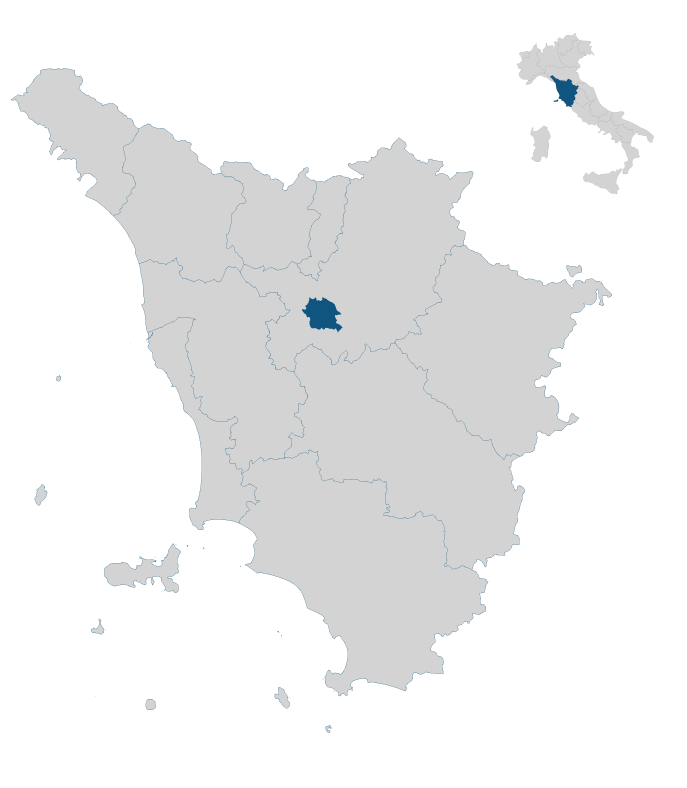
Partenza a Santa maria a Corfecciano nel Comune di di Montespertoli
https://goo.gl/maps/cuTDDvDV6VpphTT68
TEMPO DI PERCORRENZA
4h 45′
LUNGHEZZA DEL PERCORSO
km 11
DISLIVELLO TOTALE IN SALITA
m 460
GRADO DI DIFFICOLTA’
Facile
TIPOLOGIA DELLA PASSEGGIATA
Paesaggistica e storico-architettonica; percorso ad anello
RIFORNIMENTI DI ACQUA LUNGO IL PERCORSO
Si, presso alcune fontanelle
ALCUNI CONSIGLI PRATICI
Durante la stagione estiva si sconsiglia di percorrere questo itinerario nella parte centrale della giornata perché è in buona parte esposto al sole. Nel periodo autunno-invernale e primaverile va bene qualsiasi momento della giornata.
Download the brochure
Map
In the heart of Tuscany


